
Source:Island
National Surveyors’ Day fell on March 21
A surveyor is a professional person with the academic qualifications and technical expertise to practise the science of measurement, to assemble and assess land and geographic related information, to use such information for the purpose of planning and implementing the efficient administration of land, the sea and structures thereon, and to instigate the advancement and development of such practices.
An ola leaf found in Madras, written thousands of years ago, describes a surveyor thus:
“His profession will be giving estimates of lands and areas of lands, preparing plans, bills and land charges.”
Once at a seminar, held in Colombo, a leading light of the Surveyors’ Institute said that surveying was the oldest profession. A famous surgeon contradicting this, said that surveying, though an old profession, certainly was not the oldest.
“It has been held for centuries that the oldest profession is prostitution or to put it more elegantly, street-walking,” said this renowned surgeon.
“Aha,” said a professor of Engineering “to do street-walking there must be streets. And who built streets? Engineers! Then Engineering is the oldest profession.”
“Back to square one,” said the surveyor gleefully. “For streets cannot be built without surveying being done first.”
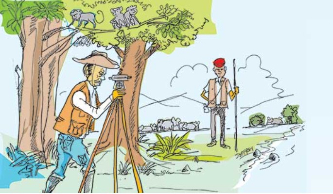
A cynic once said that a land surveyor was a man who revels at hide and seek. He begins his job by dispatching a bewildered labourer with a red and white pole into the jungles, and then spends his time trying to locate him with the eye glued to a telescope.
 The earliest reference to surveying or land measuring, is made in the Jataka Stories. According to Kurudhamma Jataka, on one occasion the king’s officers came to a border village to lay out the boundaries of a new field. The Rajjugahaka-amacca, literally, “the minister holding the measuring rope,” or in other words the Surveyor-General, gave one end of the rope to the owner of the adjoining field to hold on to his boundary and attaching the other end to a survey pole, proceeded to stretch the rope to its full measure. When about to drive the pole into the ground, he noticed that the mark was exactly on a crabhole, with the crab inside. “If I drive this pole in,” he reflected, the crab will be hurt. If I put it on one side, the king will stand to lose some of his land. If I put it on the other side the purchaser of the field will be denied his rightful extent.” This, in allegory, ventures to illustrate the integrity of the ancient surveyor.
There had been a well-ordered system of survey in ancient Ceylon, with a highly developed topographical sense. The ancient Pagodas with exact ellipsoidal shape and the low gradients of the Yoda Ela and the Jaya Ganga are marvels to be admired. The British, within four years of occupying the Maritime Areas, established the Survey Department by a proclamation, dated 2 August, 1800, issued at Point de Galle (Galle). This shows the importance the British gave to surveying, it being the first Government Department they established. Surveying developed as part of military science, hence the name Surveyor General. The first Surveyor General was Joseph Johnvillie while N.S. Perera was the first Sri Lankan Surveyor General.
The life of a surveyor was an ordeal. They pitched their own tents in the jungle, away from their loved ones, friends and relatives, for hours days and years. They had no air-conditioned offices but enjoyed the beauty of nature and the magnificent scenery, and in the night, the moon and the stars burning bright. They went to work at the break of dawn, when the birds start to sing. They had to go over difficult terrain, uneven bunds, struggle up steep hills, wade through water, walk long distances and face the hazards of the scorching sun, heavy rains, the storms and floods. Then they had to brave ticks, leeches, snakes, elephants, bears, leopards and other wild animals and live amidst mosquitoes and bouts of malaria and diarrhoea. Their camp meals were below par and had no fixed hours. The survey labourers (later survey assistants) and the shikaray (gunman) offered unstinted support. These are the stark realities of the harsh life of surveyors who were trained at the Diyatalawa Survey Camp.
Once a survey assistant was killed at Medirigiriya, by a wild elephant. At the time he was the father of an infant son. Keeping the infant in an improvised saree-cradle in his hut, his widowed wife sang this lullaby:
‘Doyya dong puthe
Bayya bang puthe
Minindoru bathe
Atha nothabang puthe’
(Beseeching the infant son, never to become a survey assistant, to lead a harsh life!).
They play a vital role in the development activities in the very important fields of agriculture, land development, irrigation, land reform, registration of title, colonization, mapping and other development projects. The surveyors were the first on land and without them it would be journeys to the realm of fantasy. Sometimes, the work of the Department was mirth-provoking. For the Bandaranaike assassination case, the Department was required to prepare a site diagram of the residence of Minister Vimala Wijewardene and to mark in it the room occupied by the Chief Incumbent Buddharakkitha Thera, and the place where he parked his car, during his nocturnal visits!
In the meantime, the trade unionists were also active. They fought for better field conditions, better camps, better pay, better postal facilities and better modes of travelling. S. R. Yapa was a militant trade unionist who had a great vision for the survey profession. He was a fiery, fearless trade unionist, far-sighted, with a no-nonsense approach. Among the other trade unionist giants were: Chappy Pate, C.S. Perera, D.L. Peiris, A.P.S. Gunawardena, M. B. Ranathunga, P.A. Robin Chandrasiri, M. Kaluthantiri, R.M. Chandrapala and several others. In 1980, lady surveyors were also recruited, in keeping with the equality of sexes promulgated in the 1978 Constitution.
They proved more than equal to the task, though the surveyors work was physically tough.
(It was noticed that with the advent of young girl-trainees, the staff of the Institute was seen better dressed!) Cupid also played his role, with several surveyor couples ending up on Poruwas. The lady Assistant Superintendents of Surveys recruited, also proved equal to the task, and went on to become a lady Surveyor General.
The Ceylon Government Ordinance No. 15 of 1889, titled the Surveyors Ordinance, gave all the authority and directions to those who opted to be private professionals in the field of land surveying. Now, it is superseded by the Survey Act No 17 of 2002. In the year 1926, the ‘Ceylon Licensed Surveyors’ Association’ was formed mainly through the efforts of Ben J. Thiedeman, H. Van Buren, M.I.L. Marikar, S. Sabaratnam, G.L. Schokman, W.P. Wickramasinghe, R.C. Dissanayake and others.
After he left school, D.S. Senanayake served in the Survey Department that came under his control years later, when he became the Minister of Agriculture and Lands. In the year 1937 he, together with G.K. Thornhill, the Surveyor General, went out of their way to help the Association. In the process Thornhill had to face an audit query. His successor L.G.O. Woodhouse was just the opposite of him. This Association was later to become the present Surveyors’ Institute of Sri Lanka. Most of its members are engaged in Court Commission Surveys with quasi-judicial powers, while in some instances they are engaged in national service, in addition to attending to the needs of the general public. In the year 1974, the Institute opened its membership to the state sector surveyors.
Mount Everest was so named after Sir George Everest, the Surveyor General of India. The first President of the United States of America, George Washington was a land surveyor. There is an interesting story about him. One day a teacher in an American School told a pupil: “Henry! at your age, George Washington was a surveyor.”
“And at your age he was the President of United States,” said the pupil.
Some survey professionals took to politics, D. S. Goonasekera and Gamini Jayasuriya were cabinet ministers. K.B. Ratnayake was a cabinet minister and also a Speaker of Parliament.
H. B. Abeyrathna was a District Minister, Sarath Welagedera and S.M. Asenkudhoos were MPs. R.L. Brohier was an outstanding surveyor produced by the Survey Department. He rose from the lower to the top most rungs of the Department. He was also a scholar, a historian, a researcher, a writer and an archaeologist. Two of his monumental works were ‘Ancient Irrigation works of Ceylon’ and ‘Land, Maps and Surveys’. In 1920, R.L.B. and his survey party were travelling through thick jungle to establish a trigonometrical station, when they surprisingly discovered the historic ‘Avukana shrine’. A digression, once Ruhunu Puthra was making an impassioned speech, at a meeting, with R.L.B. in the chair. Soon after his speech, RLB took steps to make the then 24-year-old Ruhunu Puthra an F.R.G.S.
Dr. T. Somasekeram was the head of the Institute of Surveying and Mapping at Diyatalawa for many years and retired as the Surveyor General. He was also the Chief Editor of the National Atlas and authored the book ‘Surveying Stories’, which describes vividly the life and times of the surveyors. Sunil Kusumsiri is a Licensed Surveyor who has published the book titled ‘Maimgala’ (boundary stone) in Sinhala. It provides a vivid description of the stark realities of the life of a surveyor in sylvan surroundings, sometimes laced with humour.
Across the abyss of years, the science of surveying has undergone dramatic changes with the introduction of computers, electronic distance measurements, laser technology, global positioning system using satellites, land information systems and geographical systems.


